
Today, the "official" route is via the northwest ridge and despite a trail that is in relatively good condition, ropes and all, the climb to the craggy peak of Ohulehule is still extremely steep and unforgiving. I would soon discover that the southeast ridge was the most overgrown I have ever experienced on a trail. And if that's not enough, a very nasty climb awaits you near the summit. Recent documentation of this route was made by Jeremy Kreis when he did it solo in a torrential downpour and more recently, Kaleo Lancaster and company.
I also have to mention that this ridge was also where two danish girls spent 8 days after hiking up the northwest ridge from Kahana Valley back in the summer of 1999. Once at the summit, they were intimidated by the very steep descent back down where they came from so they attempted to descend via the southeast ridge. However, that descent is twice as bad as the northwest ridge so they ended up hunkering down for over a week before the Hawaiian Trail and Mountain Club discovered them and ultimately rescued via helicopter. Read up on an article describing this rescue in detail here.
We set off on a 7am start time at the end of an unnamed road. The hike gets down to business upon leaving the road and we huffed and puffed our way through the forest to gain the crest of SE ridge. Once on the crest, the ridge opens up to the first views of Waikane, Hakipu'u valley, Chinaman's Hat, and Kualoa Ranch. True Manamana is clearly visible, showing it's suicidal backside down to 2 Apes.
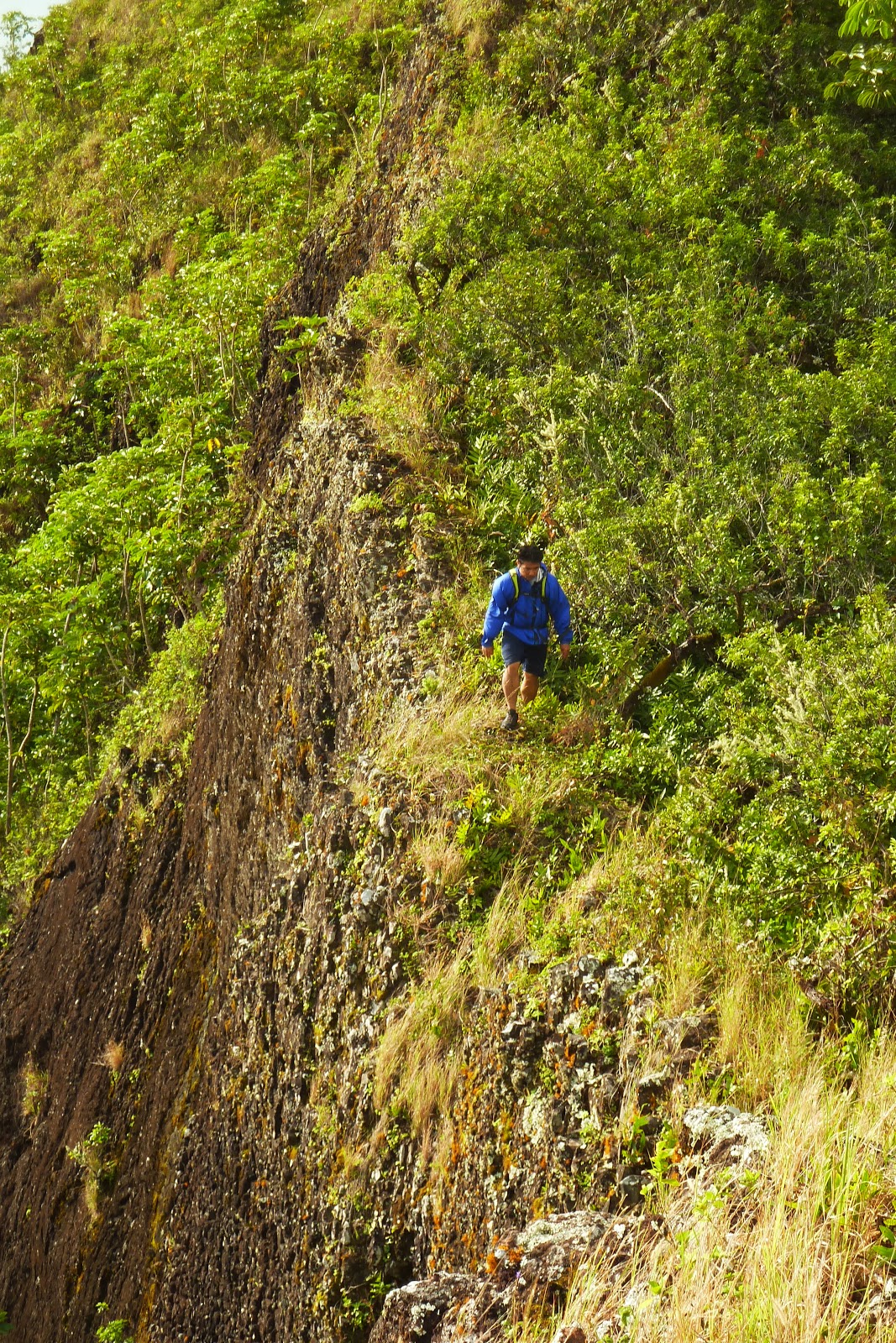
Initially, the crest walk is a pleasant one, but it is shortlived as the ridge begins it's transition to numerous rocky dike formations and the never relenting overgrowth. I have to say that the rock dikes were actually salvation for us as they served as "bridges" over the thicket, despite their sheer narrow profile! There was one particular dike that reminded me of True Manamana, although it wasn't as crumbly nor the drops as massive, but still fun to traverse. On one of the dikes, we were pelted with rain from a passing shower and treated to a wonderful rainbow as the morning sun returned.
At about the halfway point, things were not fun anymore for me and I was starting to become irritated with the overgrown "trail". As I looked ahead, the ridge continued to undulate it's way to Pu'u Ohulehule, it's summit seemingly never getting any closer. Past "mini True Manamana" dike, the ridge broaden a bit and the next few dikes were actually contoured, one on it's left and the other on it's right. It was here that we spotted an orange ribbon, left by Kaleo's group. While the contours appeared easier, it was all a deception. When we contoured, it usually mean't battling overgrowth. The trail generally remained on the Hakipu'u side during at this point.
Eventually the ridge narrows again and begins it's steep incline along the base of Ohulehule. The vegetation became more windswept and the dropoffs were more pronounced with a big drop on the left down to Waikane Valley and also on the right down to Hakipu'u Valley. Looking further south, we could see the rest of windward Oahu as far as Olomana. To the north, majestic Ka'a'awa Valley revealed herself. The Ko'olaus themselves were shrouded in wet and rainy clouds over to the west. Down below, we spotted a tour vehicle motoring about on the dirt road close to the Hakipu'u saddle. Lucky we live Hawai'i!
We admired the view but soon we would have focus all of our attention to the first cable section. It was not too difficult, but this would only be the prelude of what was up ahead a few cable sections later. On the 2nd cable, my pack got stuck on a pesky tree branch and it couldn't have happened on the most inconvenient moment as I had to devote my already expending of energy to free myself while on an extremely steep incline!
After freeing myself, I noticed a yellow rope that was severely frayed to the point of snapping. Kaleo mentioned that he snapped a yellow rope during this section. This couldn't have been the same rope as it was still in one piece, although it was seriously ready to go on the next hard tug! A couple of cables later we encountered the final climb which would be one of the most difficult climbs I've ever done. This particular cable section was probably about 100 to 150ft and it was the sheer length on an extremely steep incline that made it so difficult. It also didn't help that this entire stretch was completely eroded! Marcus was up first, then I was next and I wasn't even halfway into the climb when I could feel my upper body muscles burning! I found a spot off to the right where I could take a short break to regain some energy to finish the remaining half. I couldn't break for long as I felt the loose ground below me beginning to shift. On I went, tugging at the cable and pushing down with my feet as hard as I could, the ground crumbling below me! Thank goodness this cable was the sturdiest of all the cables and ropes! I seriously don't know how I would have been able to climb this without it! At last, I made it to the top of the cable and to a flat ledge where Marcus was hiding out. The first thing out of my mouth was "That sucked..." Marcus couldn't have agreed any better. A short while later, Francis was already at the top, completing that section in half the time I did it. Man was that guy strong! Looking back down, we could see the rest of the southeast ridge and where we started at. We were so high and the ridge appeared to curve inward as I tried to follow it with my eyes downwards, akin to the first drop of the Millennium Force roller coaster in Cedar Point! This would make one hell of a first drop if the ridge was a roller coaster! I believe the bottom of this very cable section was where the 2 danish girls spent their 8 days! It's hard to believe they were in that same spot for multiple days with very little space!
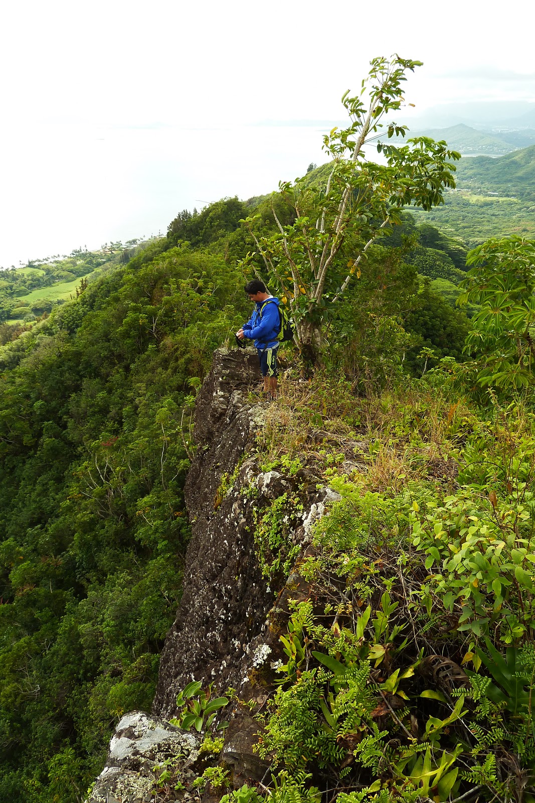
After a well deserved rest, we looked further upridge and realized that this was a false summit and the true summit was maybe 200ft up ahead. Of course life had to be difficult with the overgrowth fighting with us one last time. Fortunately, the final climb was at a much shallower and before we knew it, we were on the summit! Done.... Pau.... Finished.... Complete.... was all I could think of as I plopped my okole down on the grassy summit! The clouds briefly shrouded the summit but quickly opened up to some of the finest views on the island. The last time I was on this summit was back in November 24, 2009 and the views were still as grand as last time, albeit a bit more cloud cover. Directly below and to the left, we could make out Ka'a'awa Valley in it's entirely while the rest of windward Oahu filled the rest of the expansive views. Chinaman's Hat appeared so small in the vast blueness of the ocean. The time was about 1pm.
After taking in the beautiful vistas, we walked across the summit over to where the northwest ridge tops out and began our long and steep descent. Despite all the ropes and cables, this section was still difficult to descend. I remember Francis saying that this appeared more steep than the southeast ridge. I thought he was crazy. We completely missed the right turn off the Kahana saddle to the floor of Kahana Valley and we were unknowingly headed in the general direction of Pu'u O Kila. Maybe that's something to try one of these days. We backtracked and headed down and what perfect timing would it be to get off the ridge. During the long hike through Kahana Valley, a thundershower passed over head and we were drenched with terrential downpour as thunder echoed off the valley walls. The rainfall was actually beneficial as it kept us cool as we double timed it across 3 streams, the dam, and finally through the neighorhood to be at the car by 4pm.


Video:
No comments:
Post a Comment