Showing posts with label Palikea. Show all posts

Wednesday, June 11, 2014

Waiʻanae Mountain Range Section Hike


Well, I have to say that I am a little sad that this entry will be the last one in regards to documenting the Waianae Summit Trail.  But as with everything in life, all good things must come to an end.  I have many mahalos to all sorts of wonderful people whom I met over the years on hiking, from my very first hike up Diamond Head, to hiking and documenting the Koʻolau Mountain Range, the Waiʻanae Mountain Range, and all the hikes in between.  Some have moved on with their lives.  Others I continue to hike with to this present day.  And there are those who arrived late in my journey, but were with me down to the finish line, whether it be on the journey itself, or support from the sidelines.  Regardless, I just want to say "Thanks for helping me along the way.  Thanks for helping guide a Captain and his ship safely."  This wouldn't be possible without my very diverse crew with many different and unique qualities, not just on the trails, but in life as well.  In the end, we all have one thing in common...

Never stop exploring.

Finally, I want to thank all the people who made their journey across the mountain range prior to me, laying down the path for others to follow.  Your many years of hard work and dedication to blazing new trails will forever be carried down generation after generation.

From day 1 that I've took my very first steps on a hiking trail to today, a unique experience allowed me to open up the spiritual side of myself, to reflect deep on my thoughts, to enter a higher dimensional like state to see the world very differently.  My goal now is to take all of this and return it to the ʻāina (land) and to bring my principles with me wherever I go in this world (and one day beyond).


Waiʻanae Summit Trail Section Hike
Kaʻena Point to Makakilo (sorted by date)

11-1-2013: Kaʻena Point to KPSTS (write up) (video)
11-8-2013: Kealia to Mt. Kaʻala Rd. (write up) (video)
11-12-2013: Kealia to KPSTS (write up) (video)
11-22/23-2013: Kaʻala to Three Corners (write up) (video)
12-14-2013: Kaʻala-Kolekole Pass [Kalena] (write up)(video)
1-17-2014: Kaua - Pohakea Pass - Palehua (write up) (video)
1-25-2014: Kaua - Kolekole Pass [Hapapa] (write up) (video)


Aloha Huakaʻi Pilialoha.


For those who can't view the embedded video above can access it by following the link below: 

Wednesday, May 21, 2014

1-17-2014: Waiʻanae Summit Trail - Kaua to Pohakea Pass to Palehua

CAUTION: The Waiʻanae Mountain Range is located on properties owned by the U.S. government, the U.S. military of all branches, the state of Hawaiʻi via departments, and private owners. The mountain ridges and valleys are also home to a delicate and vast array of native plants, animals, and insects. Please take care not to disturb them or their native habitats and always seek permission to access these lands. Always do your research prior to setting out. And finally, once you are out there, always minimize your impact to the environment and of course, be safe.

Every time I drove up and down Kunia Road that connects ʻEwa to Schofield Barracks, I always look up towards the west at the Waiʻanae Mountains.  There was one geological formation that represented the mountain range's one out of two existing major "saddles".  The Koʻolau Mountain Range has the Moanalua Saddle, Kalihi Saddle, and the Nuʻuanu Saddle.  The Waiʻanaes has two, the Pohakea Pass and the Kolekole Pass.  I honestly don't know why the ones on the Koʻolaus are referred to as "saddles" and the Waiʻanaes "passes".  I know during training for my private pilot's license, pilots (at least my pilot) referred to all of them as "gaps" (ex. Kalihi Gap, Kolekole Gap).

The focus for today's section hike was the Pohakea Pass.  Reading up on previous treks and gazing at photos, the Pohakea Pass featured a 50-70ft crumbly wall on the Palikea facing side of the pass.  Not much was said about the Kaua facing side although I've read up on a blog that showed a photo of a rope wrapped around a large tree trunk and heading down a vertical rocky chute on that side.

Laredo "Muredo" a.k.a. Rainbow Man joined me on this excursion.  He had done the Pohakea Pass before and didn't mind to do it again.  We pushed off after 9am.  I won't mention our start location since it involved us doing the "T thing".  Getting past this first section would determine if the hike was even a go or not since the "trail head" was located further mauka.  Fortunately, we made it to the trail without attracting any attention and the hike was a go.

The hike started off flat through the forest, but it gradually transitioned into an incline upward.  About an hour or two in, we intersected what was probably the Honuliuli Contour Trail, a trail that supposedly contoured the windward side of the entire Waiʻanae Range from Makakilo to Kolekole Pass.  I hope that one day that this trail will get restored and offer better access to the trails heading up to the Waiʻanae Summit.  If there are any groups that are needing volunteers to restore this trail, sign me up!  Beyond the contour trail, the trail continues it's climb up towards the summit.  Some portions of it switchbacks but for the most part, it's a steep climb.  The last remaining 1/4th of the trail is on a somewhat exposed ridge that beelines it all the way to the top.  Here, one can easily see the not so far crest of the summit ridge.  Look closer and a fence is visible, tracing the entire summit.  Off to the right side, the "Gorilla Heads/Kriangles" are clearly visible.

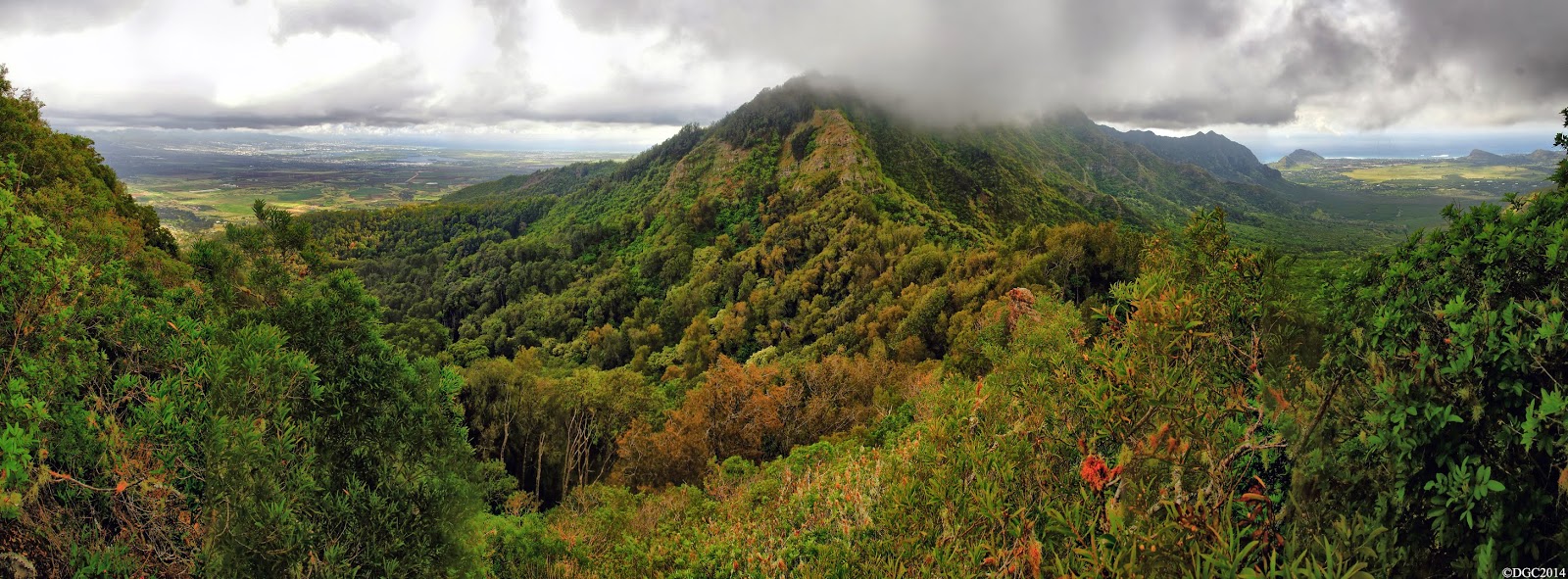
Another 30 minutes and we were standing on the broad summit of Puʻu Kaua.  The views from this peak are probably hands down the best on the entire mountain range.  To the north, flat topped Kaʻala stood tall and proud.  To the west was expansive Lualualei Valley and the west shores of Oʻahu.  To the east stood the Koʻolaus.  And finally to the south was the remainder of our route to be completed on this day.  I tried to describe the views from here but it's one of those views where you've just got to be there to know what I'm talking about.  It's phenomenal.  Seriously.  This is my favorite spot to be on the entire Waiʻanae Mountain Range.

Unfortunately, what I've just mentioned on the last paragraph was what we should have seen.  On this day, the clouds had us beat, partially.  The views to the lee side of the summit ridge was completely shrouded.  However, the windward side was clear and the views to the east were visible.  We didn't stay long on the summit though as we knew we still had a long and dangerous day ahead of us.


Pushing through the tall grass, we made our way southward.  For much of the way, this section is a nice stroll, albeit the sometimes annoying steel fence.  We enjoyed it as much as we could, as we began to prepare mentally for the next obstacle, the Pohakea Pass.


As we got closer to the pass, we could make out the gnarly looking wall on the Palikea side.  From a distance, everything looks full blown impossible and menacing.  We had to find out it's true scary profile upon reaching it's base.  We came across a series of rocky boulders that dotted the summit ridge, but most were easily doable.  There was probably one boulder that gave us some trouble.  This boulder required you to contour to the leeward or windward side of it.  I scouted the leeward side and was almost to the other side but there was a gap in foot holds.  Jumping from here to the other side could be done but I highly recommend against doing it.  We then tried the windward side, which required us dropping down about 5 to 10 ft and then contouring very carefully to gain the other side.  There is a very thin ledge that goes all the way but watch your step here.


Further down was an area where the summit ridge appeared to make a left and head downward.  We started down it briefly but I sensed that the summit ridge wasn't this at all.  We retraced our steps and looked southward, right into thick brushes.  The summit trail appeared to disappear here, but it didn't take long for us to realize that the trail continued downward in the brushes.  A blue and white rope, which was surprisingly brand new, confirmed the correct route.

We pushed downward through the thicket until we reached a somewhat clearing.  Directly filling my field of vision was the entire profile of the Pohakea Pass.  It turns out we were already descending the Kaua side of the pass, which began at the blue and white rope at the top of the brushes.  The area where the steep climb was mentioned on the other blog was no where to be seen.  The trail did become rather hidden but we kept to the crest of the ridge.


The ridge became forested with Iron Wood and a large steel object greeted us at the trough of the pass.  Near it, we spotted what appeared to be an old jeep road that contoured the mountain side.  Was this the old Pohakea Rd. that the military used to access the pass?  It was said that a guard was stationed here back in the day.


On the other side of the trough, there it stood.  We were looking head on at the crumbly wall that I've seen on photos.  Someone who completed a thru-hike of the Waiʻanaes gave this wall a name, the "Knucklehead".  We stood there for some time, figuring out how we were to attack this wall.  Just getting up to it proved a daunting task.  There was this huge rock formation that resembled a shape of a hand, a hand reaching out to you as it were inviting you to get close and personal with the wall.  Oh did we...


Laredo was up first and I followed up next.  Upon closer inspection about halfway up, a red rope was visible.  Laredo tested it and found it to be stable enough to hold weight.  Up he went and disappeared over the top.  I started crawling my way towards the end of the red rope.  The erosion here was bad.  With each crawl, loose dirt and pebbles became dislodged.  There was a relative "flat" section where I could rest easily and grab the end of the rope.  Going up past this point was critical.  Lose your footing here and you'll more than likely be plummeting down the side of the ridge.  This moment would be the gnarliest on the entire mountain range.  I called out to Laredo to see if he was still on the rope, but the only response I got was the eerie wind blowing through the pass.  The rope remained motionless so I assumed he was off it.  For that moment though, I was on my own.  It was now or never.  The hardest part was the first step off that relatively safe flat area.  With the weight of my body about half on the rope and half on the footholds, I was now completely vertical.  Nevertheless, I got to the top of the wall and Laredo greeted me, giving me a safety pull of my hand on my last stride back onto more sane ground.  I looked back and saw that the Pohakea Pass was now in our rear view mirror.  Safe!


After a much needed rest on the perch above the wall, we continued up the ridge in the direction of Puʻu Palikea.  The fence came back and we were glad to see it.  The views of Honolulu and the entire metro area were breathtaking but it also was a saddening view with all the development.


The fence disappeared into a sea of green Uluhe ferns and we were soon standing on the top of Palikea, marked by a bench mark.  Success!  The views were starting to get shrouded by the clouds but we knew we were safe.  From here on out was done on territory I was familiar with when I reached this same area from Heleakala in Nanakuli a few years ago.


From Palikea, it was a nice walk through a well manicured trail that winds it's way to the radio towers.  The hike down the paved road was long.  Very very long.  We passed by some houses marked by letters.  Night came quickly and we noticed several cars driving up.  One did stop to inform us that we were on private property but let us on our way when we told them that we were heading down.  After an hour or so, we could make out the city lights of Honolulu and the rest of the metro area.  More cars zoomed up past but didn't seem to notice us.  A truck that was heading down the road saw us and offered a ride for the last quarter mile and dropped us off at Makakilo Drive, where Jerry was waiting for us to give us a ride back home.


And that wraps up yet another adventure on the Waiʻanaes.  Just one more section left to go and this mountain range is pau (finished).

Video coming soon!

Saturday, February 5, 2011

2-1-2011: Palikea via Heleakala to Palehua

I have not heard much about Pu'u Palikea, nor Pu'u Heleakala until a couple of guys hiked this route recently.  Jeremy Kreis made it all the way to Palikea from Heleakala via a leeward ridge that connects to the Wai`anae summit crest last month.  The last recorded Palikea via Heleakala trek was back in September 1, 1997, with Dayle Turner, Pat Rorie, Laredo, Gene Robinson, and Torrey Goodman.  Wing Ng met them from the Palehua Trail behind Makakilo.  While the trail to Heleakala is in good shape, the trail beyond the low lying saddle is in very bad shape, especially at the base of Palikea.

I've enlisted the same crew who did the `Ohikilolo Rectangle with me prior to this hike: Marcus Griego and Eddie Pieters.  While Marc and I decided to "suit up" and wear long pants for the dreadful tread through the overgrowth, Eddie braved it out with shorts the whole way!  We all met at my house in Ewa Beach and carpooled to Nanakuli McDonalds for a 7:30am start time.

We walked down Naval Rd. for a short distance before veering off to the right and followed the fenceline of the nearby Nanakuli residence, making our way towards the ridgeline (There is actually a trail further mauka that also heads to the same ridge).  We passed by a pillbox during our short climb and we were soon on the crest.  I had several flashbacks of the July 18, 2009 hike up Kamaile'unu Ridge and how extremely hot that day was.  I hope we wouldn't have a repeat of that hellish excursion.

The jaunt up Pu'u Heleakala was rather uneventful and the three of us were talking stories to pass the time.  At about the same time, we got the first gleaming rays of the morning sun.  I couldn't help but think about the legend behind this peak.  Heleakala means  “where the sun is snared” or “where the sun’s rays are broken”.  According to Wai`anae folklore, the summit of Pu'u Heleakala was the site where this legendary feat took place.  Apparently there are some "conflicting" beliefs whether if Maui, a demigod, snared the sun at the summit of Haleakala ("house of the sun") on the island of Maui or on the Wai`anae coast of O`ahu at the top of Pu'u Heleakala.  According to Wai`anae tradition, Maui's mother was unable to dry her kapa clothes because the sun moved across the sky too fast.  Maui then managed to lasso the rays of the sun with his magic from the summit of Heleakala and demanded it slow down it's pace.  The sun agreed and up to this day, the sun slowed it's pace.  If this were the case, then the sun broke it's promise every winter when the days are shorter!

We topped out at Heleakala, "marked" by an abandoned tent, and we could see see the ridgeline continue it's way up to Palikea.  We got curious of a side trail that led off into the brushes.  Upon reaching it's end, we came across what appeared to be a heiau.  Not wanting to disturb the tranquility of the heiau, we kept our visit to a minimal as we quickly gazed out at the commanding view of Lualualei Valley and Pu'u O Hulu.

Beyond Heleakala, the ridge heads down into a low lying saddle which Wing Ng labels as "Despair Dip".  I would agree with him upon reaching the other side of the dip!  The California grass was thick but still manageable.  We climbed a series of small rockfaces which were nicely arranged into a pyramid style type of formation.  Looking back, we could see the massive Pu'u of Heleakala and the smooth expanse of Nanakuli Valley and the massive expanse of Lualualei Valley, dotted with roads and other military structures that were in a uniformed pattern.  I remember Eddie mentioning that some of them looked like crop circles and that aliens have landed!  Maybe he's right...

After the dip, the ridge begins a series of ups and downs and traverses a rocky dike or two.  We reached the last hump and we could see Palikea dead ahead.  "Ahh, this shouldn't be that bad.  It's just one small saddle and then the final climb to Palikea, right?"

Wrong!

Once at the bottom of the saddle, the overgrowth thickened exponentially, those small Koa trees with "explosive in every direction" branches returned, and the "path" disappeared into oblivion.  By this point, the intense sun was getting to me, although there were more scattered clouds floating about near the Wai`anae crest and this helped with providing some temporary shade.   Every now and then, we received a gentle east wind.  Somewhere along this point I lost sight of Marcus, who was the ramrod on this day, in the soup of dry foliage.  Because there is absolutely no path whatsoever to follow, I thought Marc contoured to the left of some thick brushes.  Apparently when I heard his voice, we were too far below and had to climb back up to the crest, an unncessary waste of energy.

We eventually came across a rock formation that was shaped like a mushroom, akin to the mushroom rock on Bear Claw.  Unfortunately, we would also discover more similiarities to Bear Claw as we neared the summit.

Continuing on, everything was just a mess around us.  We virtually had to find the route of least resistance.  After traversing some narrow rock dikes, we could see that our first major obstacle was looming ahead.  The "path" eventually went on the Nanakuli side of this obstacle and it was here where we would attack our first major rock face.  Eddie, being the lightest out of all us was first to climb and secured a rope.  I was up second, followed by Marc.  Immediately beyond was yet another rockface.  This one was full of handholds and footholds but nearly every one of them was on loose rock.  Another problem was the choke full of tree branches directly behind us.  There was hardly any space between the two.  This has a new meaning for "Between a rock and scratchy branches"!  Eddie had the advantage at being the smallest guy in our group and assumed the ramrod position.  He was able to rocket up these rockfaces with the least resistance from surrounding tree branches.

If it's not rock faces to scale, it's a very steep slope on dreadful Buffalo grass.  It probably goes something like this: "Rock face, grass, rock face, grass, rock face, grass..."  When the steepness of the ridge did finally ease off, we entered a forest boundary and the grass was gone for good.  Finally some relief!  I have to call that entire section starting with the very first major rock face up to the forest a "Bear Claw and a half".

We eventually came across a small clearing with some low lying uluhe (our first uluhe of the day!) and could make out the entire Wai`anae summit crest from Pu'u Kaua to our left, and the Nanakuli Forest Reserve to our right with some radio/cell phone towers to add to the mix.  Just one more small climb and we are there!  Fortunately, the climb was minor and we came across a fence (not again) and hopped it.  Beyond it was the magnificent view of the Wahiawa Plains, Pearl Harbor, and the Ko'olau Range.  Behind us was the view of Pu'u Kaua, flat topped Ka'ala, and Kamaile'unu Ridge, all lit up golden orange as the sun was very low to our west.  The time was nearly 4:30pm.  We made it at last!  It took us roughly 8 hours just to reach the summit of Palikea.

We followed along the fenceline to our right from the summit and started our way down the Palehua Trail via stairs.  I was never so relieved to see stairs after what we went through earlier today.  In fact, I was very impressed with the sheer beauty of this trail.  It's one of the best maintained on the island for sure.  The trail meandered it's way along the crest of the Wai`anae summit, contouring rather than following the crest.  We passed a rock tunnel and then a bamboo grove.  The trail eventually ends at a radio tower and our longest road walk ever on Palehua Rd towards Makakilo began.  Along the road were private houses in a setting similiar to Tantalus Rd.  What was even more intriguing was that every "household" was assigned a letter on a yellow sign.  We were at the letter "S" and I assumed the road would end at the letter "A".  Oh dear...  we have a very long way to go.  It was getting dark and out came our flashlights.  Soon a car came zooming up and hit the brakes hard, it's driver probably startled to see hikers coming down the road.  "Ahh, too bad he wasn't going down towards Makakilo!"  A short while later, a forest ranger in a truck came up the road and stopped along side of us, informing that we were trespassing and told us to climb into the back of his truck.  Apparently, the car that passed by us earlier called the forest ranger upon seeing us.  We passed by Camp Timberline and could make out the city lights of Makakilo.

After being ejected (an egress for us!) to Makakilo, the ranger identified himself as Thomas Anuheali`i, the caretaker of Palehua.  He was shocked after learning where we had started and gave us props for doing such an enduring task.  He told us he explored this spur from a top down approach, stopping just before the ridge starts it's steep descent.  He gave me his contact information and explained how to get access to Palehua Trail.  Apparently you need to deposit $100 for a key (you get it back upon return of the key) that opens one out of two gates.  The other gate is a combo lock.  I would love to go back to Palihua Trail again someday!  It's a very easy novice trail to Palikea, while at the same time, offers beautiful vistas of the leeward coast!

If I ever go back to Heleakala, I will definitely come back with a machete.  Randy Glidden, who did both left and right forks of Bear Claw Ridge with me, has plans of returning to open a trail up to the base of Palikea.  I just might very well join him!


Video: