
Every time I drove up and down Kunia Road that connects ʻEwa to Schofield Barracks, I always look up towards the west at the Waiʻanae Mountains. There was one geological formation that represented the mountain range's one out of two existing major "saddles". The Koʻolau Mountain Range has the Moanalua Saddle, Kalihi Saddle, and the Nuʻuanu Saddle. The Waiʻanaes has two, the Pohakea Pass and the Kolekole Pass. I honestly don't know why the ones on the Koʻolaus are referred to as "saddles" and the Waiʻanaes "passes". I know during training for my private pilot's license, pilots (at least my pilot) referred to all of them as "gaps" (ex. Kalihi Gap, Kolekole Gap).
The focus for today's section hike was the Pohakea Pass. Reading up on previous treks and gazing at photos, the Pohakea Pass featured a 50-70ft crumbly wall on the Palikea facing side of the pass. Not much was said about the Kaua facing side although I've read up on a blog that showed a photo of a rope wrapped around a large tree trunk and heading down a vertical rocky chute on that side.
Laredo "Muredo" a.k.a. Rainbow Man joined me on this excursion. He had done the Pohakea Pass before and didn't mind to do it again. We pushed off after 9am. I won't mention our start location since it involved us doing the "T thing". Getting past this first section would determine if the hike was even a go or not since the "trail head" was located further mauka. Fortunately, we made it to the trail without attracting any attention and the hike was a go.
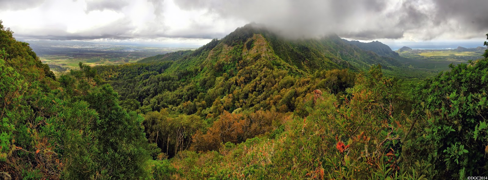
The hike started off flat through the forest, but it gradually transitioned into an incline upward. About an hour or two in, we intersected what was probably the Honuliuli Contour Trail, a trail that supposedly contoured the windward side of the entire Waiʻanae Range from Makakilo to Kolekole Pass. I hope that one day that this trail will get restored and offer better access to the trails heading up to the Waiʻanae Summit. If there are any groups that are needing volunteers to restore this trail, sign me up! Beyond the contour trail, the trail continues it's climb up towards the summit. Some portions of it switchbacks but for the most part, it's a steep climb. The last remaining 1/4th of the trail is on a somewhat exposed ridge that beelines it all the way to the top. Here, one can easily see the not so far crest of the summit ridge. Look closer and a fence is visible, tracing the entire summit. Off to the right side, the "Gorilla Heads/Kriangles" are clearly visible.
Another 30 minutes and we were standing on the broad summit of Puʻu Kaua. The views from this peak are probably hands down the best on the entire mountain range. To the north, flat topped Kaʻala stood tall and proud. To the west was expansive Lualualei Valley and the west shores of Oʻahu. To the east stood the Koʻolaus. And finally to the south was the remainder of our route to be completed on this day. I tried to describe the views from here but it's one of those views where you've just got to be there to know what I'm talking about. It's phenomenal. Seriously. This is my favorite spot to be on the entire Waiʻanae Mountain Range.
Unfortunately, what I've just mentioned on the last paragraph was what we should have seen. On this day, the clouds had us beat, partially. The views to the lee side of the summit ridge was completely shrouded. However, the windward side was clear and the views to the east were visible. We didn't stay long on the summit though as we knew we still had a long and dangerous day ahead of us.


Pushing through the tall grass, we made our way southward. For much of the way, this section is a nice stroll, albeit the sometimes annoying steel fence. We enjoyed it as much as we could, as we began to prepare mentally for the next obstacle, the Pohakea Pass.


As we got closer to the pass, we could make out the gnarly looking wall on the Palikea side. From a distance, everything looks full blown impossible and menacing. We had to find out it's true scary profile upon reaching it's base. We came across a series of rocky boulders that dotted the summit ridge, but most were easily doable. There was probably one boulder that gave us some trouble. This boulder required you to contour to the leeward or windward side of it. I scouted the leeward side and was almost to the other side but there was a gap in foot holds. Jumping from here to the other side could be done but I highly recommend against doing it. We then tried the windward side, which required us dropping down about 5 to 10 ft and then contouring very carefully to gain the other side. There is a very thin ledge that goes all the way but watch your step here.

Further down was an area where the summit ridge appeared to make a left and head downward. We started down it briefly but I sensed that the summit ridge wasn't this at all. We retraced our steps and looked southward, right into thick brushes. The summit trail appeared to disappear here, but it didn't take long for us to realize that the trail continued downward in the brushes. A blue and white rope, which was surprisingly brand new, confirmed the correct route.
We pushed downward through the thicket until we reached a somewhat clearing. Directly filling my field of vision was the entire profile of the Pohakea Pass. It turns out we were already descending the Kaua side of the pass, which began at the blue and white rope at the top of the brushes. The area where the steep climb was mentioned on the other blog was no where to be seen. The trail did become rather hidden but we kept to the crest of the ridge.

The ridge became forested with Iron Wood and a large steel object greeted us at the trough of the pass. Near it, we spotted what appeared to be an old jeep road that contoured the mountain side. Was this the old Pohakea Rd. that the military used to access the pass? It was said that a guard was stationed here back in the day.


On the other side of the trough, there it stood. We were looking head on at the crumbly wall that I've seen on photos. Someone who completed a thru-hike of the Waiʻanaes gave this wall a name, the "Knucklehead". We stood there for some time, figuring out how we were to attack this wall. Just getting up to it proved a daunting task. There was this huge rock formation that resembled a shape of a hand, a hand reaching out to you as it were inviting you to get close and personal with the wall. Oh did we...


Laredo was up first and I followed up next. Upon closer inspection about halfway up, a red rope was visible. Laredo tested it and found it to be stable enough to hold weight. Up he went and disappeared over the top. I started crawling my way towards the end of the red rope. The erosion here was bad. With each crawl, loose dirt and pebbles became dislodged. There was a relative "flat" section where I could rest easily and grab the end of the rope. Going up past this point was critical. Lose your footing here and you'll more than likely be plummeting down the side of the ridge. This moment would be the gnarliest on the entire mountain range. I called out to Laredo to see if he was still on the rope, but the only response I got was the eerie wind blowing through the pass. The rope remained motionless so I assumed he was off it. For that moment though, I was on my own. It was now or never. The hardest part was the first step off that relatively safe flat area. With the weight of my body about half on the rope and half on the footholds, I was now completely vertical. Nevertheless, I got to the top of the wall and Laredo greeted me, giving me a safety pull of my hand on my last stride back onto more sane ground. I looked back and saw that the Pohakea Pass was now in our rear view mirror. Safe!


After a much needed rest on the perch above the wall, we continued up the ridge in the direction of Puʻu Palikea. The fence came back and we were glad to see it. The views of Honolulu and the entire metro area were breathtaking but it also was a saddening view with all the development.


The fence disappeared into a sea of green Uluhe ferns and we were soon standing on the top of Palikea, marked by a bench mark. Success! The views were starting to get shrouded by the clouds but we knew we were safe. From here on out was done on territory I was familiar with when I reached this same area from Heleakala in Nanakuli a few years ago.


From Palikea, it was a nice walk through a well manicured trail that winds it's way to the radio towers. The hike down the paved road was long. Very very long. We passed by some houses marked by letters. Night came quickly and we noticed several cars driving up. One did stop to inform us that we were on private property but let us on our way when we told them that we were heading down. After an hour or so, we could make out the city lights of Honolulu and the rest of the metro area. More cars zoomed up past but didn't seem to notice us. A truck that was heading down the road saw us and offered a ride for the last quarter mile and dropped us off at Makakilo Drive, where Jerry was waiting for us to give us a ride back home.


Video coming soon!
No comments:
Post a Comment