
***NOTICE: Mariner's Ridge is CLOSED and ENFORCED by KSBE. Do not attempt to hike the Mariner's Ridge Trail. Doing so will be trespassing and can be subject to action by KSBE.***
This marks my 3rd "Nalo" (Waimanalo) hike and the 4th "Nalo" windward ridge that heads down to said town from the Ko'olau summit ridge within only two weeks! Out of all the Nalo windward ridges I've done up to date, this one takes the most overgrown award! With my Vegas trip fast approaching, I wanted to squeeze in one more hike and what another crazy adventure it would be! Joining me would be Marcus Griego, Michael Loftin, Francis Jimenez, and myself. The weather called for socked and wet summits along the spine of the Ko'olaus. The Hawaii Kai and Waimanalo portion of the summit ridge is generally dry and the weather pattern has been this way since the start of this month.
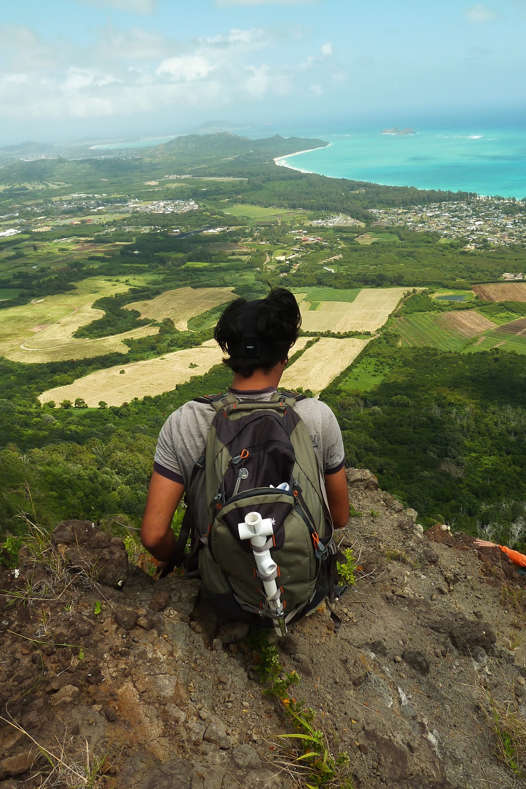
With an 8:30am start time, we hiked up the all too popular Mariner's Ridge, the quickest route to gain the Ko'olau summit ridge, overlooking Waimanalo. Once at the summit, we all peered down the steep rocky grade of the windward ridge directly below that seemed to head into a thick grove of Ironwoods. Looking westward, the summit spine disappeared into the clouds while looking eastward, the sky was a mix of blue and clouds with brisk trades.
Marcus was first to descend the steep rocky ridge and soon disappeared into the Ironwood grove. The overgrowth in that grove was so thick that it seemed if Marcus was swallowed whole. Using the plentiful branches, we descended a short drop and continued on to a clearing. However the vegetation remained thick along the crest so we were forced to edge our way around them, inching ever so close to the edge with a massive dropoff on either side. In the far distance, we spotted a red helicopter dropping off equipment to the Tom-Tom terminus, perhaps they were doing maintainence to the powerline poles there.
The ridge at last transitioned to an all rocky appearance and to our surprise, the ridge disappeared and we were confronted with a near vertical descent with several rocky ledges, all ready to give at any moment. Marcus went down first and decided against going down the direct route. He headed towards the right and downward. Eventually, we lost sight of him and I decided to start my descent, heading for the more direct route. Upon getting a closer inspection of the rest of the descent, this was actually quite similiar to the cliff face that we roped off on a descent down Hahaione Windward. With no rope anchors possible at all, we had to make do without them. Inching my way over on an extremely thin ledge about halfway down, I aimed for a rocky protrusion, but with all the cracks and faults in it, I wasn't sure if it would hold once weight was loaded on it. However due to it's massive appearance, I trusted it would hold and landed my right foot and then my left. Fortunately it held and I thought about my next move down a couple of ledges before it leveled off to a walkable grade. However, my pack was already hindering my progress and I decided to simply toss it about maybe 3 feet down to the closest ledge. At this point, the winds were howling and I attempted to compensate by aiming slightly into the wind. Unfortunately, I overcompensated and my pack smacked against a small protuding boulder and caused it to rebound forward onto the ledge I aimed for. With too much forward momentum, it rolled off the ledge and fell about 60ft down a grassy slope to the left of the ridge. Thankfully, it came to rest on some tree branches. Should it had continued beyond, it would have plunged down a massive cliff, several hundred feet down!
"To retrieve or not retrieve?" I muttered nervously as I made my way down the remaining ledges. Francis just sold me this pack the day him and I hiked the Kamiloiki to Tom-Tom hike! I decided to go for it and calmly went off the crest of the ridge to my left and down the grassy slope. Far above, I could hear the rest of the crew negotiating their way down the cliff face and my fear was that they would inadvertently dislodge a boulder, sending it my way. I yelled back at them saying that I'm directly below and to their left. However, I got no response and I was briefly on my own at this point. Fortunately, I was able to retrieve my pack and started back up the grassy slope and made it back to the crest without incident.
At a flat clearing just beyond the cliff face, I was about to reach for my water bottle when I realized the brunt force of my pack tumbling downward smashed my lunch out of it's box and decided to just eat it while I waited for the rest of the group to finish their descent. Once they made it down safely, we took a well deserved break and learned that Marcus also lost his pack when he tried to make the same attempt as I did! Apparently his pack rolled off a ledge and fell somewhere to the right of the ridge. I looked back at the cliff and was wondering how the hell he was able to retrieve it with such verticalness! That was one hell of a descent on a near vertical cliff, with rocks falling and two backpacks tumbling downward, one on each side of the ridge!
With that crazy but minor ordeal behind us we prodded on, the ridge narrowing considerably, but remaining rather level. Here, we got some of the most spectacular views of the Ko'olau cliffs to our left. It reminded me of the massive cliffs surrounding the Awa'awapuhi Extended Ridge in Kaua'i. I couldn't help but admire the view and snap several photos with the GoPro.
The ridge resumed it's downward grade through another Ironwood grove. Marcus and Michael created a sizeable gap and soon lost sight of them. Francis and I continued on and came across a section of the ridge which appeared to suddenly terminate. When we couldn't go any further, we realized they headed left and contoured a bit as they descended. A short while later as we caught up, the trail got extremely overgrown and made for slow progress at times. As we headed further downward, the Koa Trees returned with vengeance and literally transformed the trail into crawlspace like conditions. Fortunately, it was only brief and the trail opened up to more forest like conditions as we were nearing the base of the Ko'olaus.
We figured if we just simply continued hiking makai (seaward), we would eventually run into the contour trail that runs parallel to the Ko'olau base and the two powerlines that cut along it as well. We found no signs of a trail and decided to hike in a small gulch, still heading in the general direction towards makai. We spotted a pink ribbon or two but still no signs of a discernable trail. Giving up, we simply just beelined it, crashing through just about anything that got in our way. Fortunately, we made some progress as we spotted more pink ribbons and also a swath that cut through the overgrowth. Marcus marked the "junction" of MWE, carving the letters into a tree. Directly above us were the two powerlines and I knew we found the contour trail, that is, until it disappeared as we started to head back east towards Tom-Tom. At this point we were akin to a driver swerving through 6 lanes of freeway, trying to keep in a straight line. With no contour in sight, we kept going and going, using my GPS and Marcus' sense of direction to lead us. At last, we picked up the Tom-Tom Trail and realized we were so far off the contour trail as we only had to hike not even a minute before we were already at Manawaiola St. just before 1:30pm.
We proceeded to have lunch and caught the bus back to the post office just before the Mariner's subdivision where Michael and I hiked up the neighborhood to retrieve our cars.


No comments:
Post a Comment