
I was monitoring the weather forecast days prior to this hike and they were calling for an 80% chance of rain island wide. As the day drew closer, that was lowered to 50%, and finally 30%. With the odds in favor of us, I called on the 808 Goonies (Marcus, Chenay "HC GMa", Josh) along with Randy, Bogie, and Marga. We all met at 6am at the Tamura Supermarket and shoved off for the Wai`anae Kai hunting grounds.
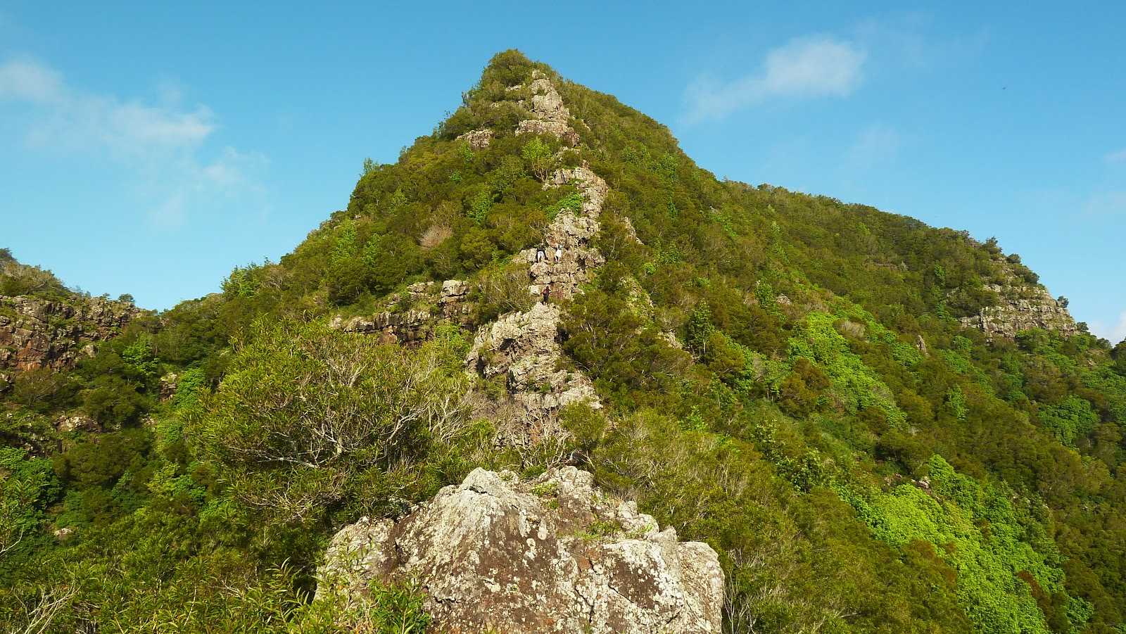
Starting off at 6:30, we began our upward grind on the paved road that snakes it's way into the deep reaches of Wai`anae Valley. After passing the water tank on our left, we veered left off the paved road by a utility pole onto an indistinctive trail that heads into the forest. Eventually it reaches a grassy clearing and one can see the imposing ridgeline that climbs up the south side of Kawiwi. The climb begins initially in sometimes thick grass then quickly transforms into scrambling up several rock faces. There's a certain point where one can see the remainder of the climb to the summit. While it appears impossible to climb, looks can be deceiving. On the worst rock faces, there's a trail that contours on it's right side, marked by ribbons, although one can choose to climb the faces directly. There was one particular rock face where I climbed it directly and upon reaching up the very top of said face and grabbing it, the whole top boulder cracked apart and I was briefly holding the boulder with my right hand! Not being able to hold the massive weight for more than a split second, I yelled out to GMa who was below me to watch out for this boulder! I deflected the boulder over to my right and sent it plummeting down below, making sure it was far away from her. Just prior to the summit, there was one last major rock face that looks totally impossible to climb but up close, one climbs on it's left side and contours over to it's far right and continues climbing upward.
We topped out at the summit of Kawiwi (2,975ft) at around 10:15am and took in the commanding views around us. Looking north, we could make out the jagged ridge line of Kea'au and `Ohikilolo Ridge. Looking south was the Wai`anae spine with Kalena, Hapapa, Kanehoa, Kaua, and Palikea. Eastward loomed flat topped Mt. Ka'ala and finally looking towards the ocean, there stood the terminus of the Kamaile'unu Ridge trail, towering high above us. I remember reading an old OHE article which recounts Al Miller's single day outing that took him up Kamaile'unu, past Kawiwi, No Name, and Ka'ala, and down Dupont to Waialua!
After about 15 minutes or so at the summit, our next stop was No Name Peak. I imagine it should have a Hawaiian name for said peak, but everyone seems to call it No Name. This section of the hike contained the very narrow dikes and it was here where I enjoyed the hike most. The first major obstacle along the dikes was a short descent that takes one along it's right side of the crest with the aid of a blue strap. We had to excercise extreme caution because at the bottom of the descent was a ledge that extended no more than 2 feet. Below the ledge was a precipitous drop that would prove fatal. Bogie did a daring jump on the first half of that descent! (Caught on video!)
We continued on the ever so narrow dike with massive drops to Makaha Valley to our left and Wai`anae Valley to our right. It then dropped down to a saddle. Eventually we came upon, you've guess it.... a fence! However this fence would prove useful as we desended the steep narrow dike. At the bottom of the saddle was a climb up a rockface with the aid of a yellow and orange strap.
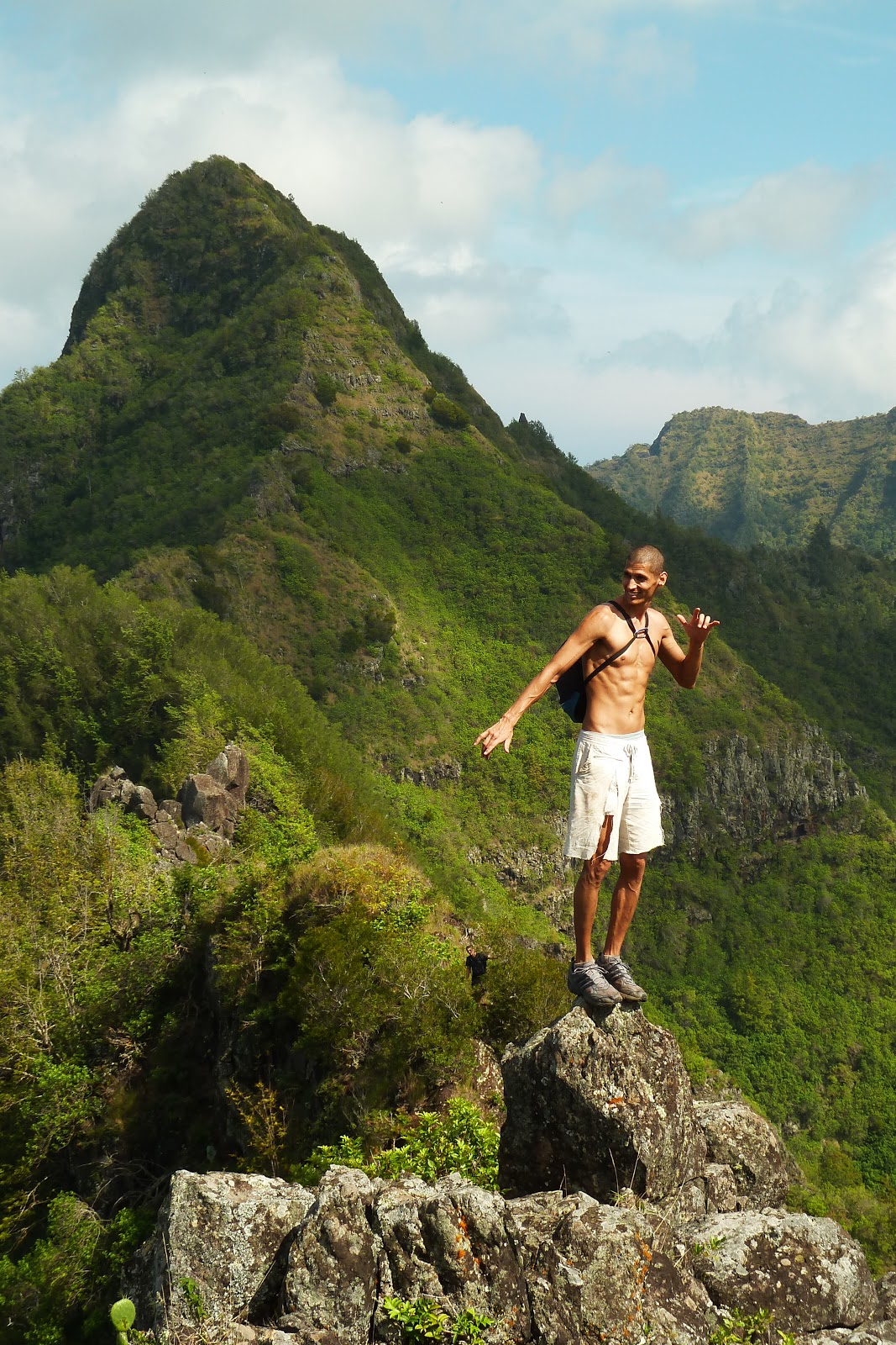
Beyond, the ridge morphed into jagged boulders that were arranged in a peculiar way, as if it were a giant jigsaw puzzle! We either contoured or climbed over the smooth rocks. We took a short break in a nice shaded flat section, the intense sun being blocked by the massive wall of rock. Eventually the ridge morphs yet again into a rather gentle stroll through Ironwoods. I've read that there existed a junction with a side trail somewhere in the Ironwood grove that drops back down to Wai`anae Valley, a good bail out route should the need arise. The Ironwoods later open up to low vegetation surrounding the ridge and one can see the massive peak of No Name. Far ahead I could see Randy, already half way up the steep ridge. How did he get there so quickly with a giant rock face that was directly below him?! I would soon find out that the climb up No Name is incredibly easy as there existed a really wide trail that contoured around and up the worst sections of the rock faces and I before I knew it, I was already with Randy and him and I waited for the rest of our group to catch up.
We reached the top of No Name (3,000ft) at around 12:30pm, just in time for lunch. Snacks and drinks were consumed while we proceeded to leave our ribbons at this summit. Looking back towards Kawiwi, the clouds were creeping up from behind us and did a spectacular "cloud dance" as the Makaha side of the ridge was socked in and the Wai`anae side completely free of clouds! Down below in Wai`anae Valley, we could hear numerous hunters whooping out, possibly to their dogs.
Two down, one to go...
As we descended the Ka'ala facing side of No Name, we could see that Tiki wasn't that far away. I wouldn't call this a "summit" in the normal sense. I guess it stands out because here is a very odd looking pinnacle of giant boulders that were arranged in such a way that it looked like a pair of Tiki torches standing tall and proud. About 50 yards or so prior to reaching these rocks, we had to traverse along a fence. We were at Tiki in about 30 minutes or less.
Once at Tiki, Randy and GMa began scouting down the south side and descended two black straps, followed by white ropes that were in horrible shape. Beyond the white ropes, they lost the trail. Apparently it didn't dawn on us that just after the second black strap (I was actually standing at that exact spot), one had to actually veer right a bit to pick up the trail that heads back down to Wai`anae Valley (There's a tiki statue on one of the trees that marks the trail). Giving up, we decided to continue along the crest towards the Wai`anae Kai Trail and the Three Poles. The fence continues past Tiki for a short while, the trail switching over from one side to the other a couple of times, requiring us to hop over the fence. Then the fence finally ends for good (Thank goodness!) and the trail comes upon a clearing that was evidence of a recent forest fire. Beyond the clearing, one can literally trail run all the way up to Three Poles as the trail was in excellent condition.
Pausing briefly at Three Poles, we gazed at the ridge, continuing it's upward rise into the now socked in summit of Mt. Ka'ala (W-K Trail). We then proceeded down from the crest and into the Wai`anae Forest Reserve via the lower half of the W-K Trail back to the paved road to complete our roughly 7 and a half hour loop hike!
Good times with great people!


Video:
Great write-up Billy Goat Dave!!
ReplyDelete