
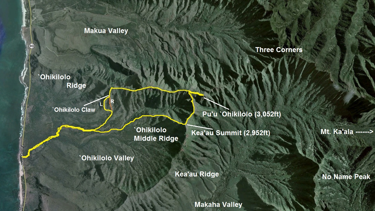
On January 26, 2011, a little over a year later, I returned back to `Ohikilolo Ridge to finish off what I've started... to summit Pu'u `Ohikilolo. However, I would use a different route which I've acquired from a recent trek by August Smith, Duc Ong, Kevin English, and Nate Yuen. They've gained the crest of `Ohikilolo Ridge by a way of a spur that resembles Bear Claw geographically. With this knowledge, I've planned a route that would ascend "`Ohikilolo Claw". Once at the crest we were to continue towards Pu'u `Ohikilolo (3,052ft) and then cross over to the Kea'au summit (2,952ft) via a connector ridge. Finally, we would drop back down to the floor of `Ohikilolo Valley and ultimately back to the starting point of our loop trail. On a map, this loop takes on more or less, the shape of a rectangle. Thus, I decided to coin it "`Ohikilolo Rectangle".
The crew for this day consisted of Marcus Griego, Eddie Pieters, and myself. Weather conditions were picture perfect, party cloudy skies with gentle trades. As we made our way down the 4x4 jeep road at around 7:30am, I looked at my GPS to see where we would veer left off the road. From the topo maps I've looked at, those guys took a route that went along a small ravine. We took said route and off we went in the general direction towards the claw. Unfortunately, there was no trail at all whatsoever and we eventually decided to just make a beeline towards our target ridge through a forest of small trees. Soon, we began to hear cows off in the distance and I thought about Mr. Silva and the Makua/`Ohikilolo Ranch. Apparently he has had problems with trespassing hikers in the past, mistaking them for poachers. I was pretty sure that we were trespassing directly on the property. We eventually came upon a fence and hopped over it, the ridge getting ever so closer. After plowing through tall grass for what seemed like an eternity, we dropped back down to a small gulch and picked up the ridge on the other side.
Checking the GPS again, we were now on our target ridge, the right fork, and it clearly showed. Up was the dominant factor for the next hour or so. After we gained some elevation, we were able to make out the "left fork" that was labeled on the topo map. Since those guys went up the right fork, we decided to contour on over to the left fork and climb up that instead. The grade was steep, but not dangerously steep, unlike Bear Claw. Any rock faces we climbed were very minor and if we did encounter a fearsome looking one, it was easily contoured. The ridge never narrows to mind boggling proportions except maybe for one small spot, but not even that was a big deal. In fact, the ridge was quite broad for much of the way up. Marcus and Eddie checked out a massive gully that was off to the left of the left fork and even spotted two goats treading about on the next ridge over. I wonder how these goats can survive in such harsh conditions with hardly any water.
There was one particular rock formation that we stumbled upon just after the junction of right fork and it was quite funny because the shape of the rock was like if the ridge was giving us the birdie. I decided to name this "Middle Finger Rock". Marcus thought it was shaped more like a dinosaur head. No Marc, this ain't no Jurassic Park! You can find that over in Ka'a'awa Valley!
Much of the climb was uneventful and we soon reached the crest and the oh so annoying fence! I thought I'd never see YOU again! On the other side of the fence was Makua Valley. The balance of sun and clouds couldn't be any better as the shadows of the clouds dotted the expansive landscape of the valley below. "Click!", said my camera! We headed mauka (inward) towards Pu'u `Ohikilolo along the crest and fenceline. While the fence was an eye sore for views and getting in the way for much of the journey, it proved useful in some of the eroded sections where it provided a security handhold. We soon came to a flat grassy area and the pyramidal shape of Pu'u `Ohikilolo beckoned a short distance ahead. We also got our first views of the North Shore. A short distance later we came upon what appeared to be some kind of camp site used by the military. An even more surprising object caught our eyes and upon closer inspection, revealed it to be a toilet! There was a wall erected on the makai side of the toilet for privacy but over to the mauka side was a grand view of Makua Valley! We peered inside the toilet, expecting a foul oder scent. But much to our surprise, it was actually very clean and the hole that was apparently dug or drilled into the ridge seemed like it went down for quite a way as we didn't see anything but a black abyss. Well folks, this is probably the only trail you will find a toilet that is perched nearly 3,000ft up in the mountains that has a magnificent view while you do your business! I decided to call this "`Ohikilolo Toilet".
Just beyond the toilet is a very eroded section. This eroded section marks the start of the connector ridge over to the Kea'au summit, which seemed so close, yet so far. Ahead was our final climb to Pu'u `Ohikilolo and it wasn't long before we were standing on top of the world.... literally. The views from up here is one of the best on the island and probably the best out of all the Wai'anae Range views, even rivaling the views from Three Corners. You can literally stand on the summit and spin yourself and watch the amazing views whirl about into a blur! The valleys of `Ohikilolo, Makua, and Makaha Valley can be seen simultaneously, similiar to Three Corners.
Reluctant to leave our throne, we made our way back down at around 1:30pm where we came from back to the eroded section to begin our cross over to Kea'au summit. I walked along a narrow dike with a massive drop to Makaha Valley on my left and a more reasonable drop to my right. Suddenly, the ground fell from underneath me and I found myself in a very brief free fall. With "quick cat like reflexes", I threw all my weight forward onto the next good sized rock and looked back to see rocks falling down on the right side. This reminded me of Mario Bros where you hop on these platforms suspended in mid air, only for these platforms to start falling and you must continue to advance forward to prevent falling down with them. I've just experienced my first real life version!
Keeping a cool head, we dropped down briefly to a very eroded area with towering and menacing looking rock formations overhead that looked like giant teeth. We read in articles that there's a goat trail that contours the Makaha side of this rock formation. We didn't find it (we didn't drop down far enough to pick up a trail), so we opted to climb over the "Teeth". Once on the crest of the teeth, we could see the rest of the jagged like dike. We either climbed up and over or contoured on the `Ohikilolo Valley side of them. Any fall here would be fatal and our lives depended on the structural integrity of these towering but extremely narrow rocks. If any of these rocks gave way, it's over.
Fortunately we all made it over without incident and we reached a strange looking area. The entire area was a rusty orange, as if we were on Mars. And if all the fences on `Ohikilolo Ridge were not enough, there's more between "Mars" and the summit of Kea'au Ridge. ::sigh::
At around 3:30pm or so we topped out at Kea'au summit and took in the views of Makaha Valley. Since I've done the `Ohikilolo Middle Ridge prior to this hike, I was back on familiar territory. I led our group back down, across the narrow dike, and back to the 4x4 jeep road. It was around 6pm when we got back to the car, thankfully still intact despite leaving it on the side of Farrington Hwy for the whole day!


Video:
Great write up Billy Goat Dave!! This was a very fun hike!!
ReplyDeletethis hike looks amazing! just wondering where you parked your car and how to get there...? this might have to be my next excursion :) love the video too! thanks for sharing
ReplyDelete